top of page
Te brindamos seís de las rutas más populares posibles desde Mariquita, sin embargo, si eres un apasionado por descubrir y hacer tu propia ruta, te recomendamos la siguiente herramienta: Wikiloc

Alto de Letras
Para los amantes del ciclismo The Longest Climb On Earth, denominada como El Alto de Letras una subida larga, muy larga que une el Tolima con el departamento de Caldas. Desde el valle del Rió Guali, pasa a través de la Cordillera Central de los Andes.
En resumen y con cifras, la subida al Páramo de las Letras desde Mariquita acumula algo más 80 km de longitud, con una pendiente media del 4% y una máxima del 11%. La altura máxima a la que se llega son a 3.667 metros sobre el nivel del mar y la subida acumula casi 3.200 metros de desnivel positivo. Tomado página clubstrava.com
En resumen y con cifras, la subida al Páramo de las Letras desde Mariquita acumula algo más 80 km de longitud, con una pendiente media del 4% y una máxima del 11%. La altura máxima a la que se llega son a 3.667 metros sobre el nivel del mar y la subida acumula casi 3.200 metros de desnivel positivo. Tomado página clubstrava.com

Honda - Plano - Guayabal
Es una de las rutas más populares para ciclistas en la región del Tolima, ideal para quienes buscan un recorrido con un balance entre tramos planos y ascensos moderados. Su recorrido cuenta con 30 km.

Circuito Mariquita
Circuito Mariquita – Fresno – Padua – Delgaditas – Alto de Letras
Esta ruta circular de aproximadamente 85 kilómetros combina ascensos y descensos, pasando por paisajes montañosos y rurales. Es ideal para ciclistas que buscan variedad en el terreno y desafíos técnicos.
Esta ruta circular de aproximadamente 85 kilómetros combina ascensos y descensos, pasando por paisajes montañosos y rurales. Es ideal para ciclistas que buscan variedad en el terreno y desafíos técnicos.

Vuelta al Tolima
Vuelta al Tolima: Ibagué – Cajamarca – Alto de La Línea – Calarcá – Pereira
Este circuito extenso, que abarca varias ciudades y paisajes diversos, es ideal para ciclistas que buscan una experiencia completa en el Tolima. Incluye el ascenso al Alto de La Línea, otro puerto de montaña emblemático en Colombia.
Imagen tomada de:
https://es.wikiloc.com/rutas-ciclismo/vuelta-al-tolima-3-ibague-cajamarca-alto-de-la-linea-calarca-pereira-26276196/photo-16785342
Autor:
Julian Calle - Bicitours Rutas

Ruta Mariquita
Ruta Mariquita – Palocabildo – Falan – Mariquita
Este recorrido de unos 56 kilómetros lleva a los ciclistas por carreteras que conectan estas localidades, ofreciendo vistas panorámicas y un desnivel acumulado de aproximadamente 1.630 metros. Es adecuada para ciclistas de nivel intermedio que buscan una experiencia enriquecedora en términos de paisaje y cultura local.
Sobre la vía que conduce hacia El Totumo, pero antes de llegar al cruce de la variante, la vereda se encuentra a mano izquierda entre una carretera destapada que expone viviendas campestres, actividad agrícola y el tránsito constante de ciclistas que encuentran allí una ruta obligada.
Tomado página ecos del combeima

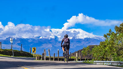
Alto la Línea desde Ibagué
Este ascenso, que inicia en Ibagué y culmina en el Alto de La Línea a 3.265 metros, es frecuentemente incluido en competencias ciclísticas nacionales. La ruta tiene una longitud de aproximadamente 21,7 kilómetros con una pendiente media del 7,6%.
Imagen tomada de:
https://es.wikipedia.org/wiki/Alto_de_La_Línea#/media/Archivo:Alto_de_la_Línea.jpg
Imagen tomada de:
https://es.wikipedia.org/wiki/Alto_de_La_Línea#/media/Archivo:Alto_de_la_Línea.jpg

Armero
Armero es una ciudad histórica y hay mucho que ver y hacer. Algunos de los principales atractivos turísticos de la ciudad son el Museo Arqueológico, la Catedral de Armero y el Parque Arqueológico Guayabo de Turmequé. Además, puedes visitar las ruinas de la antigua ciudad de Armero, que fue destruida por un volcán en 1985. Tomada Tips de viajero.com

Hacienda Nápoles
La Hacienda Nápoles es una impresionante propiedad histórica que ofrece una experiencia única e inolvidable. En la Hacienda Nápoles, tendrás la oportunidad de viajar en el tiempo y descubrir la historia y la cultura de la región. Podrás ver la impresionante arquitectura de la hacienda y sus hermosos jardines, así como visitar los parques temáticos y los animales salvajes que viven en la propiedad.
-El Parque Temático Hacienda Nápoles fue escogido por la Revista Times como uno de los 10 parques más exóticos del mundo.
-Las portadas del parque son las más grandes de su género en América Latina.
-La gran manada de hipopótamos que se encuentra allí, es la única que vive libre por fuera de África.
Tomado página web Colombia de lujo

Museo Casa de la Moneda
Esta construcción contigua a la Iglesia del Milagroso Señor de la Ermita, nos remonta con sus túneles y habitaciones secretas al período colonial. En lo alto del caballete se encuentra una granada heráldica esculpida en piedra, averiada por la chispa de un rayo que cayó por el año de 1900, este a su vez afectó en una de sus partes a la imagen del Milagroso Señor de la Ermita. Tomado red social casa de la moneda/.

La Ermita
Este templo, construido hace más de 400 años, es un ejemplo destacado de la arquitectura barroca española. Conocido como "El Señor de los Caminantes", ha sido un centro de peregrinación y es especialmente relevante durante la Semana Santa, atrayendo a numerosos fieles y turistas.

Ciudad Perdida de Falan
Es un sitio histórico ubicado en el municipio de Falan, Tolima, Colombia. Este lugar es famoso por sus antiguas minas de oro y plata, que fueron explotadas durante la época colonial por los españoles.

Casa de la Expedición Botánica
Ubicada en el corazón de San Sebastián de Mariquita, capital frutera del Tolima.
Se encuentra una vieja casona colonial en el parque principal de este municipio del norte del departamento. Dicha construcción del siglo XVIII, es la máxima expresión de la Segunda Expedición Botánica de José Celestino Mutis. Tomado el olfato.
Se encuentra una vieja casona colonial en el parque principal de este municipio del norte del departamento. Dicha construcción del siglo XVIII, es la máxima expresión de la Segunda Expedición Botánica de José Celestino Mutis. Tomado el olfato.

Alto de Letras
Para los amantes del ciclismo The Longest Climb On Earth, denominada como El Alto de Letras una subida larga, muy larga que une el Tolima con el departamento de Caldas. Desde el valle del Rió Guali, pasa a través de la Cordillera Central de los Andes.
En resumen y con cifras, la subida al Páramo de las Letras desde Mariquita acumula algo más 80 km de longitud, con una pendiente media del 4% y una máxima del 11%. La altura máxima a la que se llega son a 3.667 metros sobre el nivel del mar y la subida acumula casi 3.200 metros de desnivel positivo. Tomado página clubstrava.com
En resumen y con cifras, la subida al Páramo de las Letras desde Mariquita acumula algo más 80 km de longitud, con una pendiente media del 4% y una máxima del 11%. La altura máxima a la que se llega son a 3.667 metros sobre el nivel del mar y la subida acumula casi 3.200 metros de desnivel positivo. Tomado página clubstrava.com

Cataratas de Medina
Las cataratas de Medina hermoso balneario ubicado en Mariquita vía a Victoria (Caldas) reconocido a nivel departamental y nacional. El Río Medina de aguas frías se encuentra sobre la Vereda Orita a unos 13 kilómetros cuenta con tres saltos de más de 30 metros de altura. Es ideal para hacer senderismo o ciclomontañismo.

Nevado del Tolima
El nevado del Tolima es reconocido por los montañistas colombianos y de todo el mundo, dada la dificultad en el ascenso, resultado de sus empinadas y escarpadas cumbres de lava que constituyen el cono volcánico. Tomado de Wikipedia

Nevado del Ruiz.
El Nevado del Ruiz forma parte del Parque nacional natural Los Nevados e incluye otras cumbres nevadas como las de los Nevados del Tolima.
Santa Isabel, El Cisne y Quindío, las cuales están cubiertas por glaciares que han ido retirándose de manera significativa desde 1985 a causa del calentamiento global. El parque es un popular destino turístico e incluye varios refugios para los turistas; las laderas del volcán son utilizadas para deportes de invierno, y la Laguna del Otún, para la pesca de trucha.9 Así mismo, en la región se encuentran algunos balnearios con aguas termales operados comercialmente. Tomado de Wikipedia
Santa Isabel, El Cisne y Quindío, las cuales están cubiertas por glaciares que han ido retirándose de manera significativa desde 1985 a causa del calentamiento global. El parque es un popular destino turístico e incluye varios refugios para los turistas; las laderas del volcán son utilizadas para deportes de invierno, y la Laguna del Otún, para la pesca de trucha.9 Así mismo, en la región se encuentran algunos balnearios con aguas termales operados comercialmente. Tomado de Wikipedia
bottom of page